| Did You Know? |
Greenbrier County
![]()
![]()
![]()
|
Mother of the Southern Tier of Counties Greenbrier County was created by an act of the Virginia General Assembly in October 1777, that act becoming law on March 1, 1778, and providing also for the formation of Rockbridge and Rockingham Counties (VA). Greenbrier was carved from Botetourt and Montgomery Counties, and embraced a territory of what is now in whole or part, of the following counties: in Virginia, Allegheny and Bath; in West Virginia, Braxton, Calhoun, Clay, Fayette, Gilmer, Jackson, Kanawha, Mason, Monroe, Nicholas, Pocahontas, Putnam, Roane, Summers, Webster, Wirt, and Wood.
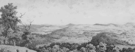
Edward Beyer’s lithograph depicting the view of Greenbrier County as seen from Little Sewell Mountain.
The county takes its name from the Greenbrier River that flows through it and the prickly vines by the same name that grew abundantly along the river. Greenbrier is the second largest county in West Virginia; Greenbrier State Forest and part of the Monongahela National Forest are located here. Some familiar towns in the county include: Alderson, Frankford, Lewisburg, Maxwelton, Quinwood, Rainelle, Renick, Ronceverte, Rupert, White Sulphur Springs and Williamsburg.
|
Copyright © 2005. All rights reserved